Names and borders in the area now known as Turkey have changed so many times that it’s difficult at first to understand the region that the Crusaders were approaching. The few educated priests among them probably knew the New Testament names of some of these places. The writings of Paul and Jesus’ disciples used Romanized version of Greek colonies.
After leaving Nicaea, the Crusaders crossed the Roman province of Galatia, which included cities to whom Paul had addressed his Letter to the Galatians. Galatia was a very wide plateau, averaging 1000 feet above sea level, so at first they followed a steep road from Lake Ascanius up into the plateau. In modern times, Ankara is in the center of this plateau.
The plateau ends in the east by going up into the higher mountains or, right at the coast, going sharply down again to sea level. There was one much-used pass that led down to the wide coastal plain of Cilicia; it has always been called the Cilician Gates. Two huge boulders act as gateposts to a narrow pass that’s only wide enough for a modern road. Modern Turks call it the Gulek Pass (picture). Invading armies must go through the pass in a long line, though not quite single-file. Since ancient times, the pass has been guarded by a fortress.
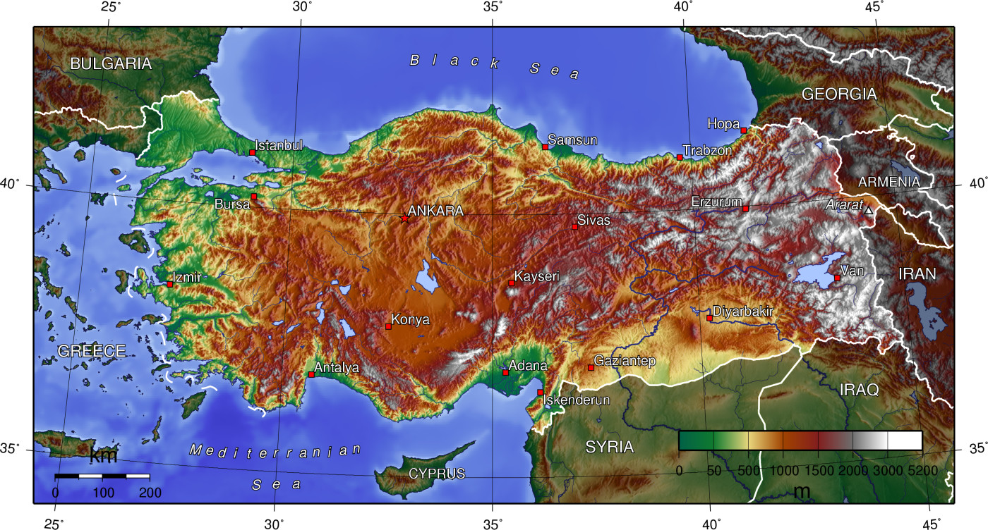
Look at this topographic map of Turkey. The modern town of Adana is located in the middle of the Cilician coast plain, and just to the left, you may notice white higher elevations with a break in the middle. That’s the pass. Apostle Paul’s home town of Tarsus was in Cilicia, near modern Adana. When the Crusaders went through the Cilician Gates, they were now in the Holy Land, in their minds.
Go back to the topo map of Turkey, and look way to the east, to Armenia. Right at the border is the mountain marked Ararat. It’s in this mountain range that Noah was said to land in the Ark. A very ancient indigenous nation, the Armenians, claimed that their founding ancestor was Noah’s great-grandson Hayk. They believed that while other descendants drifted away, the family of Hayk remained in the foothills of Ararat, spreading down into the plateau toward the Mediterranean. Their capital city, in the early Middle Ages, was just east of modern Gaziantep. It was called Edessa in Greek; its original name appears to have been something like Urhay, and in modern Turkey it’s called Urfa or Sanliurfa. At the height of Armenian power, they ruled from Cilicia (the fortress at the pass was Armenian) through the mountains, over to the shores of the Caspian Sea.
The Armenians did not have a port, originally, so they allied and cooperated with whoever lived in the nearest Mediterranean cities. Greek settlements ringed the Mediterranean coast, so the nearest port towns were Tarsus, Antioch, Latakia and Tripoli. Latakia and Tripoli were further down into modern Lebanon, but Antioch is still on the topo map of Turkey. It’s called Antakya in Turkish, but if you look for it on Google Maps, try Hatay, which is also the name of the province. It’s just south of Iskendurun.
Antioch was a major Roman port and it had become a center of Syrian Orthodox Christianity. It was located on the Orontes River, which winds very slowly through Syria and forms part of a very squiggly, oxbowed border between Syria and Turkey. The Orontes River was unusual for the region because it flowed from south to north; although it was merely following its course downhill, local people had generalized that rivers flowed north to south—except for this one. The river was not very useful for travel, but it formed a lake at Antioch (now drained) and created a wide floodplain for farming and foot travel. So a great deal of ancient settlement was along the Orontes River.
Armenia’s traditional close ties to Antioch led to its being one of the first non-Greek nations to accept the new doctrine of Jesus. Although Armenia was integrated with its Greek and Aramaic neighbors to some extent, its unique language and culture also kept it isolated. Armenians developed their own church traditions and were not part of the Greek Orthodox network. (Here is a video of Armenian music to accompany the Lord’s Prayer. “Hayr Mer” means “Father Our.” Hayr is a cognate of Latin Pater.)
Going back to the green triangle of Cilicia (modern Adana), this region had changed a great deal just before the Crusade. The Seljuk Turks entered Byzantine Anatolia only after stampeding across Armenia. Armenian refugees crowded up into the mountains (where modern Armenia is located) and down into Cilicia, where they could expect some Byzantine protection. So Cilicia had become an Armenian enclave; later it was even its own “Kingdom of Armenia in Cilicia,” but at this time it was still a frightened refugee population. Several Cilician cities, including Tarsus, had already fallen to the Turks.
A few cities dominated the region in 1097:
–Edessa, still the Armenian capital;
–Antioch, still an active port;
–Aleppo, called in Paul’s time Berea, terminus of the Silk Road travel;
–Damascus, the ancient capital of Arameans and Syrian Christians, but now a regional Muslim seat of government;
–Tripoli, the Greek name for the tri-city zone of Tyre, Sidon and Arados, and traditionally a ship-building powerhouse due to the good timber in Lebanon;
and Jerusalem. Because it was holy.
Armenian Edessa was still independent of Turkish rule, though its sovereignty was shrunken to just the zone near the city. Antioch, Aleppo, Damascus, Tripoli and Jerusalem were all part of the Muslim Empire, but at this time they were led by warring Turkish governors. This is the land that the Crusaders now entered by the Cilician gates, climbing down from 1000 feet to sea level.